OUR ITINERARY MAP
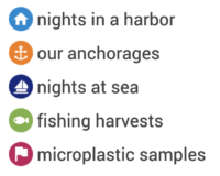
Here is a map on which you can follow the entire route of our journey. You will find the different ports where we stayed, our anchorages, our nights at sea, our fishing harvests and of course our microplastic samples.
LEGEND

World plastic production has increased exponentially from 2.1 million tonnes in 1950 to 147 million in 1993 to 406 million by 2015.
Some 700 species of marine animals have been reported so far to have eaten or become entangled in plastic.
Around the world, nearly a million plastic beverage bottles are sold every minute.
OCEANEYE’S MAP
We are one of the various volunteer sailboats collecting microplastic samples for Ocean Eye. They contribute to scientific research by conducting campaigns to collect and analyse samples of ocean surface water. Here is the map showing all our samples already taken and analyzed. To see all the samples currently collected by the all volunteer sailboats, click on “maps & tools”, “layers & legend” and select all.
LEGEND

ECO-FRIENDLY SAILOR’S MAP
We joined other sailors to create together an eco-friendly sailor’s map. When traveling by sailboat, we go from harbor to harbor without knowing the local “tricks” to remain zero waste. This card allows us to gather information from different markets, local producers, bulk stores, … and makes life easier for environmentally conscious travelers.
The more we are, the more information we have to share! Don’t hesitate to send an email to EcoArvik if you have addresses or if you want to contribute! ecoarvik@exocean.org
In collaboration with Eco Arvik.
FOLLOW US
Check our latest adventures on your favorite social network !


